Updated: 2026-07-23 06:27 CEST
Locality
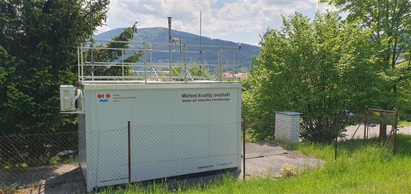
| Locality: |
Prachatice
|
|
| Code: |
CPRAA |
| Type of measuring programme: |
Automated measuring program |
| Locality owner: |
Czech Hydrometeorological Institute |
| Abbreviation: |
B/S/R |
| Coordinates: |
49° 0´ 57.912" North latitude 14° 0´ 1.600" East longitude |
| Altitude: |
583 m |
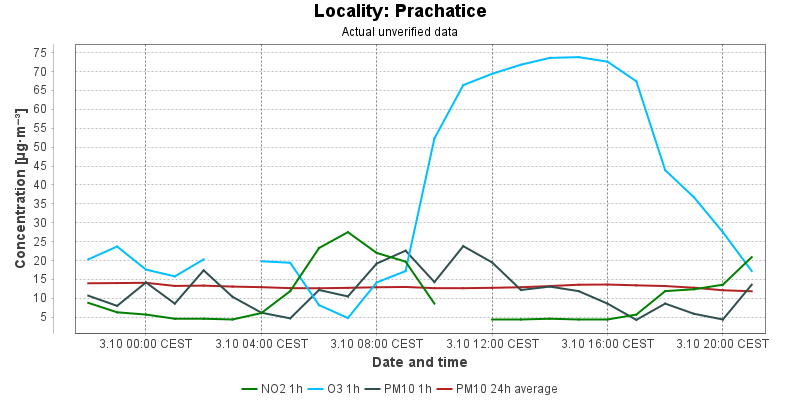
Actual measured level of air pollution
Actual unverified data
| 2026-07-22 06:00 - 07:00 CEST |
|
|
1.0 |
|
37.5 |
52.7 |
5.7 |
7.2 |
|
| 2026-07-22 07:00 - 08:00 CEST |
|
|
1.0 |
|
41.7 |
50.5 |
15.3 |
7.0 |
|
| 2026-07-22 08:00 - 09:00 CEST |
|
|
1.0 |
|
79.6 |
53.4 |
25.3 |
7.5 |
|
| 2026-07-22 09:00 - 10:00 CEST |
|
|
1.0 |
|
83.6 |
56.9 |
12.8 |
7.7 |
|
| 2026-07-22 10:00 - 11:00 CEST |
|
|
1.0 |
|
89.6 |
60.4 |
13.5 |
8.1 |
|
| 2026-07-22 11:00 - 12:00 CEST |
|
|
1.0 |
|
88.0 |
63.9 |
7.3 |
8.2 |
|
| 2026-07-22 12:00 - 13:00 CEST |
|
|
1.0 |
|
88.6 |
68.0 |
11.1 |
8.5 |
|
| 2026-07-22 13:00 - 14:00 CEST |
|
|
|
|
87.8 |
74.6 |
6.4 |
7.9 |
|
| 2026-07-22 14:00 - 15:00 CEST |
|
|
3.4 |
|
87.6 |
80.8 |
3.3 |
7.5 |
|
| 2026-07-22 15:00 - 16:00 CEST |
|
|
|
|
87.4 |
86.5 |
2.3 |
7.3 |
|
| 2026-07-22 16:00 - 17:00 CEST |
|
|
4.4 |
|
90.2 |
87.8 |
12.2 |
7.6 |
|
| 2026-07-22 17:00 - 18:00 CEST |
|
|
4.0 |
|
93.4 |
89.1 |
7.9 |
7.8 |
|
| 2026-07-22 18:00 - 19:00 CEST |
|
|
4.6 |
|
97.0 |
90.0 |
5.4 |
7.7 |
|
| 2026-07-22 19:00 - 20:00 CEST |
|
|
3.3 |
|
97.0 |
91.1 |
6.5 |
7.7 |
|
| 2026-07-22 20:00 - 21:00 CEST |
|
|
3.4 |
|
94.8 |
91.9 |
4.9 |
7.7 |
|
| 2026-07-22 21:00 - 22:00 CEST |
|
|
4.2 |
|
93.6 |
92.6 |
3.9 |
7.7 |
|
| 2026-07-22 22:00 - 23:00 CEST |
|
|
9.9 |
|
79.6 |
91.6 |
10.9 |
7.8 |
|
| 2026-07-22 23:00 - 00:00 CEST |
|
|
3.4 |
|
92.8 |
92.3 |
6.0 |
7.7 |
|
| 2026-07-23 00:00 - 01:00 CEST |
|
|
3.8 |
|
87.6 |
92.0 |
5.1 |
7.8 |
|
| 2026-07-23 01:00 - 02:00 CEST |
|
|
3.3 |
|
84.2 |
90.8 |
15.0 |
8.3 |
|
| 2026-07-23 02:00 - 03:00 CEST |
|
|
2.5 |
|
85.8 |
89.4 |
8.2 |
8.4 |
|
| 2026-07-23 03:00 - 04:00 CEST |
|
|
2.5 |
|
|
88.3 |
4.7 |
8.5 |
|
| 2026-07-23 04:00 - 05:00 CEST |
|
|
2.7 |
|
83.0 |
86.7 |
3.5 |
8.4 |
|
| 2026-07-23 05:00 - 06:00 CEST |
|
|
3.3 |
|
81.0 |
84.9 |
7.8 |
8.5 |
|
|
|
Component is not measured |
|
|
Incomplete data |
|
|
Limit exceeded |
Map of station position
Map is on page with detailed information about locality