Updated: 2026-07-23 06:27 CEST
Locality
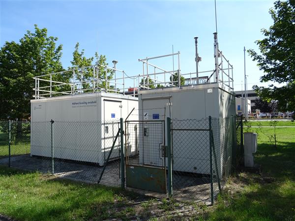
| Locality: |
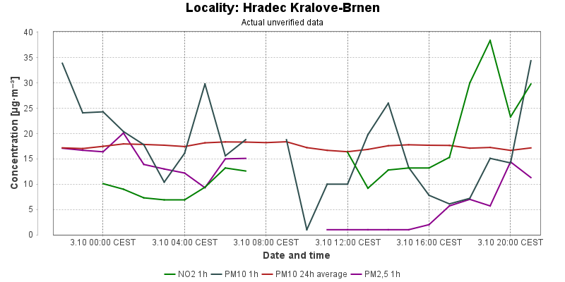
Hradec Kralove-Brnen
|
|
| Code: |
HHKBA |
| Type of measuring programme: |
Automated measuring program |
| Locality owner: |
Czech Hydrometeorological Institute |
| Abbreviation: |
T/U/RC |
| Coordinates: |
50° 11´ 43.304" North latitude 15° 50´ 46.955" East longitude |
| Altitude: |
232 m |
Actual measured level of air pollution
Actual unverified data
| 2026-07-22 06:00 - 07:00 CEST |
|
|
|
330.2 |
|
|
9.0 |
8.6 |
4.7 |
| 2026-07-22 07:00 - 08:00 CEST |
|
|
12.1 |
331.5 |
|
|
10.7 |
7.9 |
3.4 |
| 2026-07-22 08:00 - 09:00 CEST |
|
|
11.3 |
334.5 |
|
|
17.0 |
8.0 |
2.7 |
| 2026-07-22 09:00 - 10:00 CEST |
|
|
7.5 |
337.7 |
|
|
8.8 |
7.9 |
9.1 |
| 2026-07-22 10:00 - 11:00 CEST |
|
|
4.8 |
340.5 |
|
|
18.4 |
8.5 |
7.3 |
| 2026-07-22 11:00 - 12:00 CEST |
|
|
3.3 |
342.3 |
|
|
9.6 |
8.7 |
7.1 |
| 2026-07-22 12:00 - 13:00 CEST |
|
|
3.6 |
343.5 |
|
|
21.9 |
9.6 |
6.6 |
| 2026-07-22 13:00 - 14:00 CEST |
|
|
5.7 |
347.3 |
|
|
11.5 |
9.9 |
4.9 |
| 2026-07-22 14:00 - 15:00 CEST |
|
|
4.4 |
346.0 |
|
|
7.4 |
10.1 |
3.4 |
| 2026-07-22 15:00 - 16:00 CEST |
|
|
4.0 |
344.7 |
|
|
5.4 |
10.2 |
4.6 |
| 2026-07-22 16:00 - 17:00 CEST |
|
|
4.4 |
342.3 |
|
|
13.8 |
10.3 |
7.6 |
| 2026-07-22 17:00 - 18:00 CEST |
|
|
3.4 |
340.2 |
|
|
10.0 |
10.4 |
9.3 |
| 2026-07-22 18:00 - 19:00 CEST |
|
|
4.6 |
339.7 |
|
|
10.5 |
10.4 |
7.0 |
| 2026-07-22 19:00 - 20:00 CEST |
|
|
6.1 |
340.6 |
|
|
21.7 |
10.9 |
4.7 |
| 2026-07-22 20:00 - 21:00 CEST |
|
|
6.5 |
344.4 |
|
|
26.9 |
11.7 |
5.4 |
| 2026-07-22 21:00 - 22:00 CEST |
|
|
5.2 |
346.4 |
|
|
26.3 |
12.6 |
7.1 |
| 2026-07-22 22:00 - 23:00 CEST |
|
|
4.4 |
348.6 |
|
|
16.1 |
12.8 |
5.1 |
| 2026-07-22 23:00 - 00:00 CEST |
|
|
3.8 |
350.5 |
|
|
9.8 |
12.9 |
4.4 |
| 2026-07-23 00:00 - 01:00 CEST |
|
|
5.2 |
351.7 |
|
|
7.6 |
13.0 |
3.5 |
| 2026-07-23 01:00 - 02:00 CEST |
|
|
7.1 |
352.8 |
|
|
4.1 |
12.9 |
4.9 |
| 2026-07-23 02:00 - 03:00 CEST |
|
|
6.5 |
351.7 |
|
|
3.6 |
12.8 |
4.8 |
| 2026-07-23 03:00 - 04:00 CEST |
|
|
8.0 |
349.6 |
|
|
5.0 |
12.8 |
4.8 |
| 2026-07-23 04:00 - 05:00 CEST |
|
|
5.7 |
335.1 |
|
|
4.9 |
12.4 |
4.0 |
| 2026-07-23 05:00 - 06:00 CEST |
|
|
|
331.0 |
|
|
17.5 |
12.4 |
12.0 |
|
|
Component is not measured |
|
|
Incomplete data |
|
|
Limit exceeded |
Map of station position
Map is on page with detailed information about locality