Updated: 2026-06-15 05:27 CEST
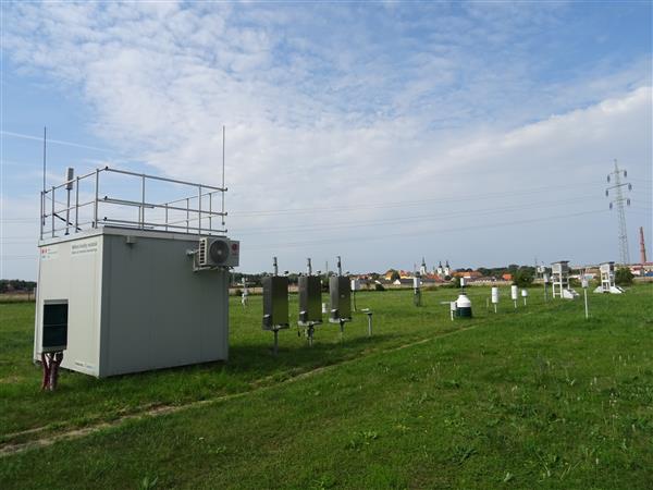
Locality
| Locality: |
Doksany
|
|
| Code: |
UDOKA |
| Type of measuring programme: |
Automated measuring program |
| Locality owner: |
Czech Hydrometeorological Institute |
| Abbreviation: |
B/R/NA-NCI |
| Coordinates: |
50° 27´ 31.877" North latitude 14° 10´ 12.584" East longitude |
| Altitude: |
158 m |
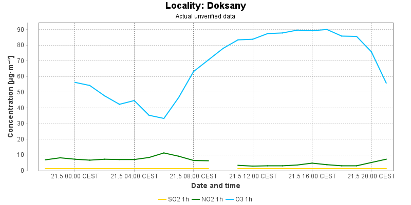
Actual measured level of air pollution
Actual unverified data
| 2026-06-14 05:00 - 06:00 CEST |
1.3 |
2.0 |
2.7 |
|
60.6 |
46.8 |
|
|
|
| 2026-06-14 06:00 - 07:00 CEST |
3.5 |
2.1 |
4.8 |
|
58.5 |
45.0 |
|
|
|
| 2026-06-14 07:00 - 08:00 CEST |
5.1 |
2.3 |
5.0 |
|
63.4 |
47.3 |
|
|
|
| 2026-06-14 08:00 - 09:00 CEST |
2.9 |
2.4 |
2.9 |
|
63.2 |
50.2 |
|
|
|
| 2026-06-14 09:00 - 10:00 CEST |
|
2.4 |
|
|
63.4 |
53.8 |
|
|
|
| 2026-06-14 10:00 - 11:00 CEST |
3.2 |
2.4 |
2.1 |
|
65.8 |
56.8 |
|
|
|
| 2026-06-14 11:00 - 12:00 CEST |
2.9 |
2.5 |
2.3 |
|
69.0 |
61.6 |
|
|
|
| 2026-06-14 12:00 - 13:00 CEST |
1.3 |
2.5 |
1.0 |
|
67.6 |
63.9 |
|
|
|
| 2026-06-14 13:00 - 14:00 CEST |
1.3 |
2.5 |
1.0 |
|
69.8 |
65.1 |
|
|
|
| 2026-06-14 14:00 - 15:00 CEST |
1.3 |
2.4 |
1.0 |
|
72.8 |
66.9 |
|
|
|
| 2026-06-14 15:00 - 16:00 CEST |
1.3 |
2.4 |
1.9 |
|
72.2 |
68.0 |
|
|
|
| 2026-06-14 16:00 - 17:00 CEST |
3.2 |
2.5 |
2.1 |
|
71.6 |
69.0 |
|
|
|
| 2026-06-14 17:00 - 18:00 CEST |
3.7 |
2.5 |
4.2 |
|
69.0 |
69.7 |
|
|
|
| 2026-06-14 18:00 - 19:00 CEST |
3.7 |
2.5 |
2.9 |
|
68.8 |
70.1 |
|
|
|
| 2026-06-14 19:00 - 20:00 CEST |
2.9 |
2.5 |
2.3 |
|
67.2 |
69.9 |
|
|
|
| 2026-06-14 20:00 - 21:00 CEST |
6.1 |
2.6 |
5.4 |
|
63.2 |
69.3 |
|
|
|
| 2026-06-14 21:00 - 22:00 CEST |
2.7 |
2.5 |
3.8 |
|
61.6 |
68.3 |
|
|
|
| 2026-06-14 22:00 - 23:00 CEST |
3.2 |
2.6 |
2.3 |
|
64.0 |
67.2 |
|
|
|
| 2026-06-14 23:00 - 00:00 CEST |
5.3 |
2.8 |
4.4 |
|
|
66.5 |
|
|
|
| 2026-06-15 00:00 - 01:00 CEST |
4.0 |
2.9 |
2.9 |
|
59.1 |
64.7 |
|
|
|
| 2026-06-15 01:00 - 02:00 CEST |
3.2 |
2.9 |
2.9 |
|
54.5 |
62.6 |
|
|
|
| 2026-06-15 02:00 - 03:00 CEST |
3.2 |
3.0 |
3.6 |
|
51.9 |
60.2 |
|
|
|
| 2026-06-15 03:00 - 04:00 CEST |
2.9 |
3.0 |
3.8 |
|
51.9 |
58.0 |
|
|
|
| 2026-06-15 04:00 - 05:00 CEST |
1.3 |
3.0 |
4.0 |
|
47.9 |
55.8 |
|
|
|
|
|
Component is not measured |
|
|
Incomplete data |
|
|
Limit exceeded |
Map of station position
Map is on page with detailed information about locality